
Trollskogen (The enchanted forest)


Magical forest on Öland’s north-eastern cape
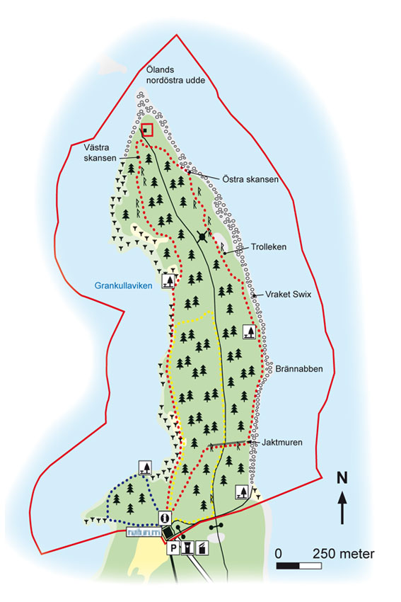
Trollskogen (The enchanted forest) is situated at the tip of Öland’s north-eastern cape (nordöstra udde). It is an old grazed coniferous forest that truly deserves its name. It is the home of gnarled windswept pines and old oaks with wide crowns. The magical feeling is enhanced by ivy running along the ground and up tree trunks. Trollskogen is one of Öland’s most popular and most frequently visited locations.
Pearls of the forest
Cattle grazing has given Trollskogen an open character with gaps in the trees here and there, and the rare Chimaphila umbellata grows here, as does the little almond scented twinflower. The presence of old hollow trees and dead wood allows many insects, tree fungi and lichens to thrive in Trollskogen, such as the rare bark lichen. The breeding birds in the area include black woodpeckers and red crossbills. This is also the best location on Öland to see the willow tit, one of the island’s rarest breeding birds.
Shingle and fishing grounds
Mighty beach ridges of shingle have formed on Öland’s north-eastern cape over the millennia, shaped by wind, waves and ice. Atlantic herring and European flounder can be found in the surrounding coastal waters. Grankullaviken bay is a very important “nursery” for many fish species.
Ancient sites
The north-eastern cape has had great significance for humans since prehistoric times, due to the rich supply of fish and the harbour at Grankullaviken. Prehistoric burial sites are situated like a string of pearls on older beach ridges along both sides of the headland. The cape’s strategic location is also highlighted by fortifications from the 1400s, when the Danes tried to occupy the former naval base of Örbovik. At the headland’s narrowest point there is a hunting wall that was probably built by Johan III in the 1500s.
Facts:
Size: 266 ha (657 acres) of which 115 ha (284 acres) is land
Year of creation: 1998
Purpose: To preserve an area of natural coniferous forest, ancient oak trees, grazed coastal meadows and coastal and shallow areas with their typical flora and fauna.
Directions/Location:
Öland’s nordöstra udde (north-eastern cape), is about 65 km from Borgholm. Follow route 136 north and turn towards Grankulla just before Byxelkrok. Signs show the way from Grankulla.
GPS coordinates to the parking lot WGS 84 decimal (lat, long): 57.34280 , 17.11920
Karta: Naturcentrum AB, Stenungsund.
Download: the County administrative boards brochure over (in Swedish only) (795 kB): Trollskogen
Download: the entire brochure (in Swedish only) (19 MB): Utflyktsguide Öland
© Lantmäteriverket, Ur Geografiska Sverigedata, översiktskartan Dnr. 106-2004/188”
Source: County Administrative Board, Kalmar
Translation: Visitoland.com