
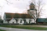
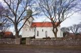
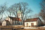
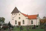
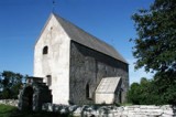
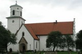
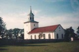
Ås Church
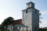
Church environment Ås Church is located adjacent to the eastern main road about 5 km from the southern tip of Öland and is the island’s southernmost church. Both the church and the cemetery is located just inside the wide and high wall, “Karl X’s wall”, which cuts across the island and separates Ottenby “Kungsgård” (Kings …Continue Reading
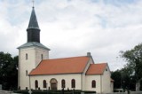
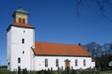
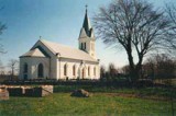
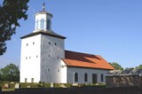
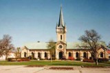
Vickleby Church
Church environment Vickleby church is located up on the edge of the fault line, just west of the western main road. From the cemetery you have a view of the barren “stora Alvar” (the Great Alvar) in the east and the fertile valley with Vickleby village in the west. East of the cemetery is “Vickleby …Continue Reading
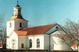
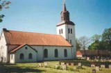
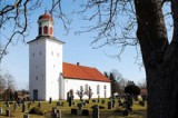
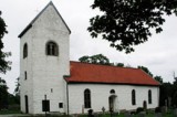
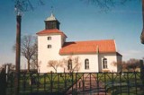
Ventlinge Church
Church environment Ventlinge cemetery encircles the church on the slope of the western fault line just east of the western main road, not far from Grönhögen. From the cemetery, you can see the Kalmar Strait in the west. The area between the cemetery and the main road consists of a small park which also houses …Continue Reading
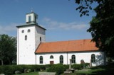
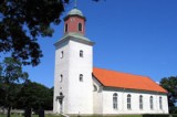
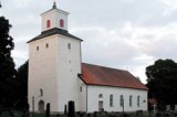
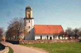
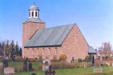
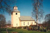
Södra Möckleby Church
Church environment The church and the cemetery have a central location in Southern Möckleby village, the main road towards Ottenby in the south and Färjestaden the north passing west of the church and along the road are a few shops including a grocery. West of the cemetery is the Church park that was laid out …Continue Reading
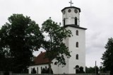
Stenåsa Church
Church environment Stenåsa church and the cemetery located along the eastern road between Föra in the north and Ottenby in the south. The parish lies between Sandby and Hulterstad parishes in height with Resmo on the west side. The church is located in the northern part of the village. East and west of the church …Continue Reading
Smedby Church
Church environment Smedbychurchis slightlywest of the westerncountry roadandfrom the cemeteryyou have a view of theKalmar straitin the west.Around thechurchin the south andeast isagricultural land. To the west lies a red wooden building that was built in the 18th century butin a different location. In 1848it was moved toSmedbyand became thevicarage,whichit wasuntil 1929, on the plot …Continue Reading
Segerstads Church
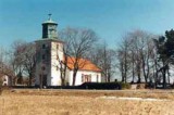
Church environment Segerstads church and the cemetery is on the south east coast of Öland at the east main road in the southern part of Segerstad village. Around stretches arable and pasture land and the Alvar out. South of the cemetery is the former vicarage and just north of the cemetery next to the main …Continue Reading
Sandby Church
Church environment Sandby parish is situated on the eastern side of Öland, almost in level with Färjestaden. The church and the cemetery lies a few kilometers east of the main road that runs along the eastern side of Öland from Föra in the north to Ottenby in the south. Around the church there are several …Continue Reading
Resmo Church
Church environment Resmo church and cemetery is located on the west side of Öland on the fault line overseeing the fertile Mörbylånga valley. West of the church is the former elementary school, built in 1868. South of the cemetery and the road towards Kleva is the old junior school from the 1920s. School and education …Continue Reading
Norra Möckleby Church
Church environment N Möckleby church is located on the eastern side of Öland along the road that goes from Föra in the north to Ottenby in the south. The church is located in the northern part of the village where today there are both older buildings and new residential areas. South of the church is …Continue Reading
Mörbylånga Church
Church environment Church and Cemetery in Mörbylånga parish is located on the low fertile coastal plain and not, as most of Öland’s churches, on or near the fault line. Mörbylånga village already existed in the Middle Ages. On the oldest map from 1641, it has been interpreted as the vicarage plot was located a little …Continue Reading
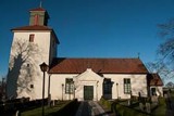
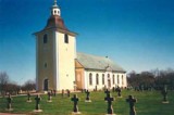
Kastlösa Church
Church environment Kastlösa church is located on the eastern fault line near the western country road in the northern part of Kastlösa village. Immediately west of the cemetery is Kastlösa “stiftsgård” (diocesan study center). When the new church was built in the 1850s, then a new vicarage was also built and the old one was …Continue Reading
Eketorps Borg
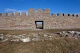
Borgen Eketorps borg, landets enda totalundersökta och rekonstruerade fornborg, har ett mycket högt vetenskapligt och pedagogiskt värde och är ett av öns mest uppskattade besöksmål. Läget Eketorp är den sydligast belägna av de öländska fornborgarna. Den är strategiskt placerad 1,7 kilometer från Östersjön, mitt ute på Stora Alvaret. Inom borgen finns en källa som …Continue Reading
Gettlinge Gravfält
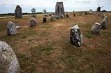
Gravfältet Gettlinge gravfält är en fornlämning i Södra Möckleby socken på södra Öland. Gravfältet är ett av de största på Öland, med en längd av nästan två kilometer. Det är beläget längs öns västra väg mellan byarna Gårdstorp, Gettlinge och Klinta. Gravfältet beskrevs av historikern Johannes Haquini Rhezelius i hans “Monumenta runica”, från 1634. Han …Continue Reading
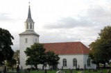
Hulterstad Church
Church environment Hulterstad church and cemetery is located on the south eastern side of Öland, at the height of Kastlösa on the west side. The road from Föra in the north to Ottenby in the south which connects villages and communities on the eastern side of Öland goes through the village. The church is located …Continue Reading
Gårdby Church
Church environment Gårdby church and cemetery is located where the road which runs along the eastern side of Öland from Föra in the north to Ottenby in the south, meets one of the roads to Törnbotten and Färjestaden. Here has a small community of detached houses emerged. In the community were earlier service functions as …Continue Reading
Gräsgård Church
Church environment Gräsgård church in the south-east of Öland is like many of the churches in the east of Öland, located on the east fault line, consisting of beach ridges formed during the various stages of development that the Baltic gone through. On the eastern fault line is the main road and along this the …Continue Reading
Algutsrum Church
Church environment The church and the cemetery is situated high on the fault line in the western part of the parish. Route 136, which extends from the northern to the southern end of the island goes past Algutsrum just below the fault line. The church and the cemetery form the center of the village of …Continue Reading
Räpplinge Church
Church environment Räpplinge church is located next to the road between Borgholm and Gärdslösa. A few hundred meters east of the church is a hillock called “Tingsbacken”. East of the cemetery is the church cottage. In the open space south of the church are the old elementary school built around 1850 and the new elementary …Continue Reading
Runstens Church
Church environment Runstens church is located on the eastern fault line in the south of Runstens village. Past the cemetery to the west is the southern village street, and from the west the road from Glömminge connects. Outside the cemetery wall to the west is the church grounds and across the road the parish hall …Continue Reading
Persnäs Church
Church environment Persnäs parish is situated on the northern Öland between the parishes Föra and Källa. The Church Village is located a few kilometers east of the road 136th The church is surrounded by farmland but the parish’s most important industry has long been quarrying. West and south of the church are the remains of …Continue Reading
Löt Church
Church environment Lots church and cemetery is located at the intersection of the road 137 on the eastern side of Öland and the road to Alböke. Adjacent to the church a small center evolved where there were a shop, school, etc. East of the church is the vicarage. The manor house that exists today was …Continue Reading
Långlöts Curch
Church environment The church is located on the northern part of the burial ground used from 200-300 BC and up to the 11th century. The church is not directly connected to any village, its located on the eastern fault line between the villages Långlöts and Folkeslunda. South of the church lies the former vicarage, the …Continue Reading
Köpings Church
Church environment Köpings church and cemetery is located along road 136 in the midst of Köping. The area has a very long history and was during the Iron Age, a trading center on the island of Öland. The parish is therefore rich in ancient remains. Northeast of the church is one of the more remarkable; …Continue Reading
Källa gamla Kyrka (The old Church in Källa)
Church environment The old Church in Källa is located along the road to Källa Harbour. Källa Harbour was for a long time one of the north-eastern Öland’s most important harbours. Around the church lies Vi Alvar (The typical moor of Öland) with plenty of ancient remains from the Iron Age. The church and its surroundings …Continue Reading
Källa Church
Church environment Källa church and cemetery located in the village “Vi” along road 136 in northern Öland. Previously, the main road passed near the church in the east but today it passes outside the village. At the church is the small village with houses, and there is still a local shop. North of the church, …Continue Reading
Högsrums Church
Church environment The church is located next to the road between Rälla and Gärdslösa. Around the church is pastures and Alvar (the typical Moorland of Öland). East of the church grounds is the parish house decorated in a whitewashed two-story house with a tiled roof from the 1820s. The house was formerly community hall, poorhouse …Continue Reading
Högby Church
Church environment Högby church and cemetery is located east of the community Löttorp, along road 136. When the railway was built in 1906 was Löttorp one of the important stations along the railroad. During the 20th century has northern Öland’s service and trade been concentrated to Löttorp. Here are today among other things, school, health …Continue Reading
Gärdlösa Church
The Church environment Gärdslösa church and cemetery is located adjacent to and west of the road between Bredsätra and Långlöt, north of the villages of North and South Gärdslösa. The church is located above the fault line and just north of the church environment is Störlinge southern “Kvarnbacke” that is a burial ground with single …Continue Reading
Föra Church
Church environment Föra church and cemetery is located at the intersection where the roads along Öland’s eastern and western side meet. East of the church site is the village Föra, one of the row villages on Öland. West of the church, is the school, which was built in 1927. The school ceased in 1995 and …Continue Reading
Egby Church
Church environment Egby church and cemetery is located midway between the two villages Egby and Sandby along the road that runs from Föra in the north to Ottenby in the south along the eastern side of Öland. The parish is located due east of Köpingsvik on the island’s northern half. The two villages are typical …Continue Reading
Böda Church
Church environment Böda parish is the most northerly parish on Öland. The church and the cemetery are located along road 136 on the road’s west side, in the southern part of Böda. North of the church is the rectory that was built in 1839, today a private residence, and further north of the church is …Continue Reading
Bredsätra Church
Church environment Bredsätra church and cemetery is located on the eastern side of Öland at the height of Borgholm. Around the church is a small community with mixed buildings including several houses built in the 1950s. Opposite the church is the road to Sikavarps harbour with the ruin of Sikavarps Chapel and the lighthouse. …Continue Reading
Borgholms Church
Church environment Borgholms cemetery is located in the northwestern part of the city. The place is surrounded in the north by a strip of beach towards the Kalmar strait, in the east of “Kapelludden” camping, in the south by Sandgatan and Bäckmans Park and in the west by the port area. What once were the …Continue Reading
Alböke Church

Church environment Alböke church and cemetery is located about 15 km north of Borgholm. The village and the church are located along the country road’s old route just east of what is now the path of road 136. The church is surrounded by farmland and in the village are several farms. The Church In …Continue Reading